By Kristoffer Edlund
Numerous industries have a need for aerial operations but cannot justify the expense of manned aircraft. With the comparatively low purchase and operational cost of multicopters, however, the required budget is far more reasonable. Despite the reduced cost, some degree of pilot skill is still required and continues to pose a barrier to entry in this revolutionary field. At the hobbyist level training time is less of an issue, as pilots can practice as much as necessary and damage or loss of an aircraft rarely has consequences beyond the cost of repairs. In commercial applications crashing a drone leads to expensive downtime and loss of profit, and in military and similar uses could lead to mission failure and even loss of life.
Maneuvering a drone through an unstructured environment, especially near ground level, is challenging under the best of circumstances. When the operator is flying beyond their line of sight and must rely on telemetry the challenge is even greater. Surveying disaster sites, performing search and rescue operations or any other low altitude flight requires the pilot to be fully aware of their surroundings at all times and to fly with extreme caution. Maintaining this level of situational awareness is difficult, and even trained military pilots have surprising difficulty controlling aircraft remotely. For inexperienced pilots focused on carrying out additional mission objectives the challenge is even greater. Most roles for rotorcraft do not require an ace drone pilot, but do require the pilot to have skills in addition to flying. Automating most of the piloting process frees operators to focus on these supplementary skills and to do their jobs more effectively.
Actually building a drone that flies itself, however, is more difficult than it might seem. Although advanced sensing packages and motion planning algorithms have existed for many years, applying them to rotorcraft is difficult. Such vehicles have the ability to travel rapidly in any direction and to change course almost instantly. The former characteristic is especially challenging, because it requires mapping the drone’s surroundings on all sides, as well as above and below, at all times. The majority of available rangefinders are highly directional, meaning they have a limited field of view and must be used in combination to get a complete spherical model of an environment. Sensors are also limited by their sampling rate, or the speed at which they can update readings, which is critical during rapid flight.
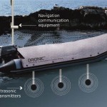
Recognizing these challenges, student researchers at the University of Utah are developing an integrated sensing and obstacle avoidance package to integrate with existing multirotor hardware, allowing anyone to safely operate a drone with a minimum of training. The Autonomous Quadcopter Project implements an array of 6 ultrasonic rangefinders refreshing 20 times per second and capable of locating objects around the vehicle to less than a centimeter. This high frequency sampling allows the system to effectively detect obstacles even when the drone is flying at full speed. Ultrasonic sensors, however, suffer beam profile limitations which results in blind spots between sensor modules (for those unfamiliar with the technology, Brown University has an informative overview of ultrasonic sensing). High speed flight is most common in areas free of obstruction and along a single direction, so the high speed sensors are oriented to provide maximum coverage directly ahead and behind, and to the left and right. For slower flight and complex maneuvering, a scanning LIDAR (Laser Induced Differential Absorption Radar) system provides a complete environment map. While providing a much more complete image of the surrounding environment, the LIDAR system suffers from a slow response rate and is unsuitable for high speed flight.
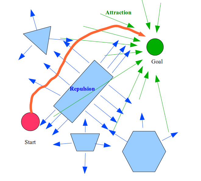 A Potential Field Planner algorithm combines the output of both sensor suites and generates a map of the drone’s surroundings, where the location of each obstacle is a vector measurement having both direction and magnitude. The inverse vector sum of these measurements indicates the direction of least obstruction and a suggested magnitude of travel in that direction. By adjusting course to follow this resultant vector, obstacles can be avoided. Current work is underway to increase the efficiency of the motion planner software and improve integration with commercially available multirotor platforms.
The goal of this project is to provide an integrated “black box” solution for semiautonomous aircraft control, whereby the pilot can attempt to fly in the direction they want to go and the drone will automatically correct course to avoid obstructions. This removes much of the stress from the pilot and allows them to focus on the role the aircraft is performing instead of simply trying not to crash. Automated navigation systems of this type significantly reduces the time and monetary cost barriers in many potential drone markets and have the potential to extend this novel technology well beyond its present predominantly hobbyist following and allow integration with a wide range of industries.