Drone deliberately flown at plane above Essex sparking terror fears
Published October 25, 2014The UK Airprox board is worried that an ATR72 turbo-prop airplane’s near crash with a quadcopter is just the beginning. The plane was coming in to land at 1,500ft when the pilot saw a quadcopter flying along the edge of the right wing of the plane. Apparently, drones such as this one have been seen in the area before, but this near-collision is the first incident of this magnitude in the UK. Security officials are worried that this close encounter is a sign of things to come. Some are beginning to worry that drones are going to be used similarly in the hands of terrorists.
Abu Dhabi Police drones now have you in full HD
Published October 25, 2014Meanwhile in Abu Dhabi, seven new drones will soon be sent out to capture high definition day and night footage. The drones are intended to allow for increased media coverage of disasters and events. They can transmit video directly to the Central Operations Room, allowing officials to make quick educated decisions in times of crisis. An operator and a controller are assigned to each drone, ensuring that proper attention is paid to drones during flight. But what of the implications of these drones? Do people have to be mindful of every step they take out of their doors? It’s a question that people are increasingly asking themselves as drones become more commonplace.
Shiffer: Look, up in the sky: It’s super-drone
Published October 26, 2014On a more positive note, the Federal Aviation Administration gave Tim Briggs permission to fly his yellow drone for commercial uses. Briggs, a retired member of Navy, has a history of working with aircraft. After performing maintenance on manned planes in Afghanistan and flying unmanned vehicles as a hobby, Briggs offered to help the Le Sueur County with digital imaging. The Le Sueur County agreed to a deal where they will pay Briggs around $500 to $750 per square mile of land photographed. The images will be used to map out drainage ditches. Briggs was adamant about the fact that his company, AeroLogix GIS, is not spying on people. He is proud to proclaim that his twenty-three pound craft, costing between $5,500-$6,000, is the first authorized commercial drone in Minnesota.
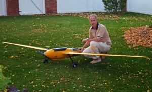
Photo: Tim Briggs